

The second half of my Oregon Trail journey, west to east, began at Riverton, Wyoming, on the Mississippi side of the Continental Divide, where the Rendezvous of 1838 took place. The Rendezvous was an annual convention in the wilderness for American/English/French explorers, trappers, traders and Indians that took place somewhere on the high plains for 15 years. In 1822, William Ashley cofounded the Rocky Mountain Fur Company and advertised for “enterprising young men, to ascend the river Missouri to its source, there to be employed for one, two, or three years.” His men became known as “Ashley’s Hundred,” and their Rendezvous continued until 1840, when the market for beaver pelts collapsed.
Brown road signs (our standard for cultural attractions) are posted on the highway in Riverton. The Rendezvous site is on a bend in the Wind River, at the southeast corner of the Wind River Reservation, past decaying mobile-home parks and industrial buildings on a rutted road. No sign narrates its significance. If you didn’t know about the Rendezvous, the site is a gravel lot with a boat ramp. To me, having imagined it from books, it was hallowed ground.
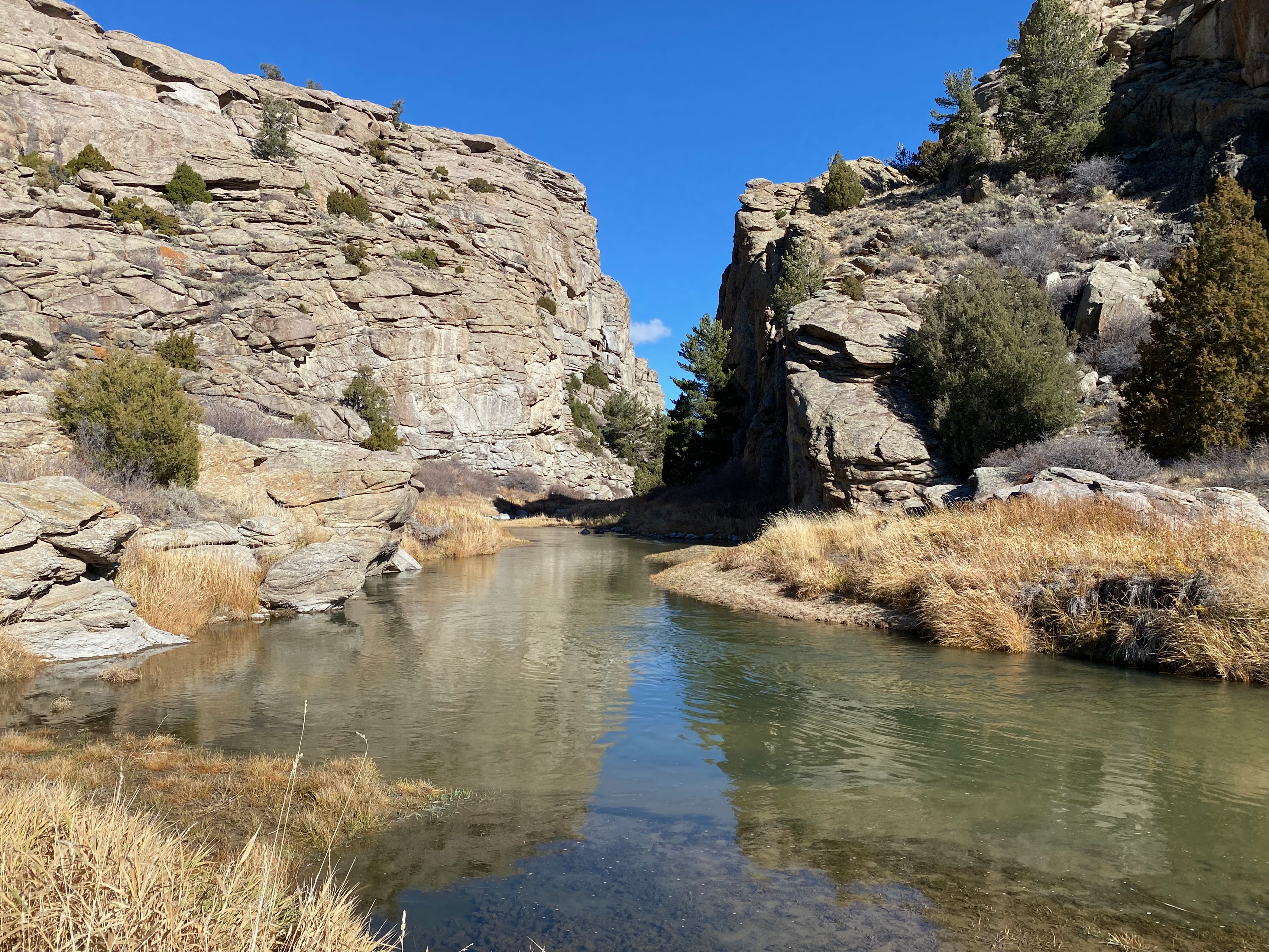
The day before, at the Route 28 rest stop down the hill from South Pass, I had noticed the Sweetwater River running under the highway. About a hundred miles east, the Sweetwater cuts through Devil’s Gate, a volcanic cliff 400 feet high. I turned left off the highway and spent a couple hours here. Just west of the cut is Martin’s Cove, a nook in the hillside that takes its name from a group of Mormons who tried to make the trip to Salt Lake too late in the season and took “shelter” there. The LDS church owns some of the land and, after a political squall, leased more from the Bureau of Land Management.
Brigham Young sought to bring emigrants from the British Isles, and several thousand made the trek in the late 1850s. Young decided the emigrants, departing with guides from Iowa City, could push and pull $10 handcarts rather than walk beside oxen-led wagons. Many made the journey without incident. But two of these handcart companies, led by men named Martin and Willie, were delayed in 1856. A series of events culminated in the deaths, between Fort Laramie and Martin’s Cove, of perhaps 20 percent of the parties, twice the typical fatality rate on the Oregon/California/Mormon Trail. No one knows precisely how many people died of hunger, cold and disease.
In 1872, Tom Sun built a homestead a few hundred yards up from Devil’s Gate. The Sun Ranch is across the Trail from Fort Seminoe, still standing, a supply station founded by a Frenchman, Charles Lajeunesse. The ranch, the fort and the fissure are the focus of this site, sacred to the LDS. It’s a place for me to contemplate the Trail and its costs.

A friendly LDS couple have been volunteer hosts here since April. We discussed the disastrous judgment of Martin and Willie. Devil’s Gate is only six miles west of Independence Rock, another landmark on the Trail, so named because the conventional wisdom was that Overlanders needed to arrive by July 4 to make it through Oregon’s Blue Mountains before winter. (Of course, Salt Lake is closer than Oregon, but the rock should have given them pause before leaving Fort Laramie, far to the east.) I remarked to my hosts that what we see here is man’s dilemma: the belief that God will provide versus the corresponding faith that God gave us brains to abort a mission ahead of predictable conditions, like the arrival of winter on a windswept prairie.
The whole day from Riverton, 268 miles, was a humbling experience in Wyoming’s great emptiness: mountains and sagebrush and undulations and striking stone landmarks that guided the Overlanders toward the horizon. The frosted morning gave way to a pleasant afternoon in the 50s after my elevation fell to 5000 feet at Casper. There I stopped at one of the Trail’s interpretive centers, an impressive collection of artifacts and narrative-telling. But I was psychically and physically exhausted from contemplating the journey of two centuries ago. At dark I stopped at a motel in Wheatland, a dot in the middle of landscape.
The Guernsey Ruts
The next morning brought surprises and pleasures on the border approaching Nebraska. At the Guernsey Ruts, wagon wheels cut sandstone into a roadway next to the North Platte. The ruts illustrate the Overlanders’ numbers, more than a half-million in the middle decades of the 1800s. Just downriver is Register Cliff, where the passing Emigrants chiseled their names into rock—beside faded petroglyphs carved by previous passersby, and where people continue to carve their names, or in one case an opinion: “Fuck Trump.”
Guernsey is upriver from Fort Laramie, the first settlement in Wyoming and then the logistical base for the U.S. Army’s war against the Indians of the Northern Plains. Many of the buildings were restored in the 1950s; others are ruins. I’m not terribly interested in military operations on this trip; it’s the courage and imagination of the trappers, explorers and Overlanders following Indian paths that grip me. Clayton, a Park Service ranger who’s spent a decade at the fort, was only too happy to find a fellow history student; our conversation, uninterrupted by any other visitor over 45 minutes, ranged from historiography to journalism to favorite authors and their works. He directed me to the next Trail highlight.
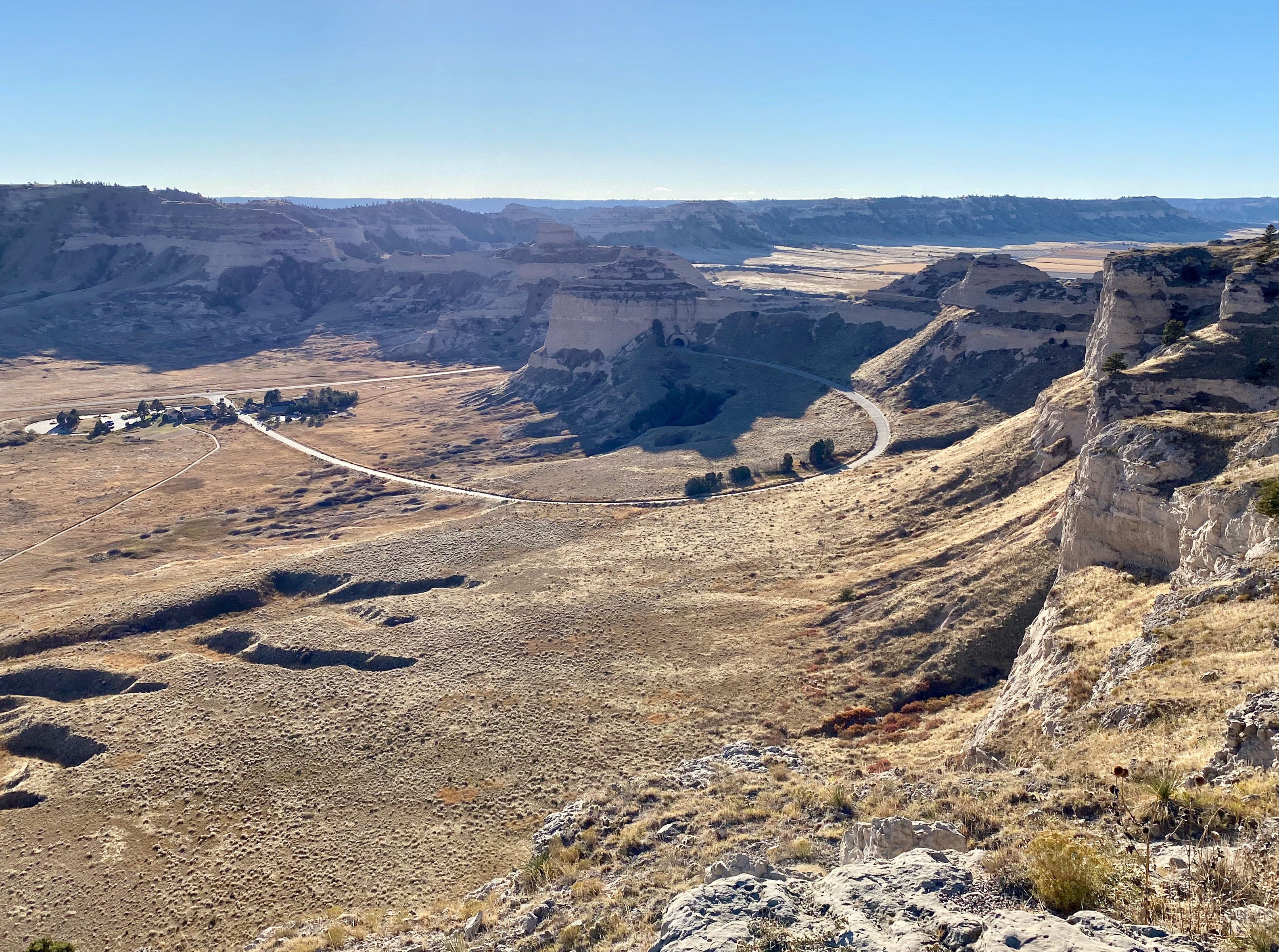
That was over the Nebraska border and unmarked by road signs. The Rubidoux Pass is an early Emigrant trail that marks a topographical shift from the Great Plains to the uplifts of Wyoming. A dirt road runs by the edge of it: a wide, gentle swath with a panoramic view east and west. After a few years the Overlanders shifted north to Scott’s Bluff, a landmark with a steeper climb but closer to the North Platte, on the butte’s north side. The Park Service has built a road to its summit, a majestic view in all directions. Hiram Scott was one of “Ashley’s Hundred”; he got sick on the way to the 1828 Rendezvous and was left behind. When the company returned the following year and found a skeleton, they named the pass for him.
A hundred miles east of Scott’s Bluff, I camped on the shore of Lake McConaughy, created by a dam on the North Platte. The next morning I stopped in Lexington at the Dawson County Historical Museum, a collection of folk objects since the pioneer days: a few buildings were moved here, and a warehouse displays cars, a biplane, a barber shop, agricultural implements, household goods, and military uniforms from wars over a century. I met a woman who had grown up in the county, lived all over the place (including Portland, where she drove Uber for four years), and in later life moved home to marry a high school sweetheart she’d rediscovered on Mark Zuckerberg’s evil empire.
A few miles east, the Phelps County Historical Society maintains a shrine to the Plum Creek Massacre on the south edge of the Platte. Over two days in August 1864, the Sioux, Cheyenne and Arapaho mounted a coordinated attack on White settlements across the region in a vain effort to reverse the tide of encroachment. Missing from the narrative is any mention that the Emigrants, bolstered by the aggression of the U.S. Army, were transforming prairie grass into farms and chasing away the bison. Instead the plaques focus on the day: “Ranches, stage stations, homesteaders’ cabins, and wagon trains were attacked and burned. Men, women and children were killed outright or captured. Some captives were tortured and killed, some were ransomed.”
I veered north of the Oregon Trail at Kearny, site of the Archway, a museum straddling the highway, and spent the night in Lincoln, Nebraska’s second largest city. (Six Saturdays each fall, the state’s third largest is inside the stadium where the Cornhuskers play football.)
The Homestead Act
Forty miles south of Lincoln, within a stone’s throw of the Big Blue River and not far from the Trail, is Homestead National Historical Park. It sits on the first land patent deeded under the 1862 Homestead Act, which provided title to settlers who filed claims of 160 acres (a quarter-section under Jefferson’s 1785 township system) and lived on and improved it over five years. The first grant went to Union scout Daniel Freeman, who filed his claim on New Year’s Day 1863 and lived there until his death in 1908. (This would be context for the Plum Creek Massacre the following year.)
The federal government processed 1.6 million homestead applications over the next seven decades, constituting a tenth of U.S. lands in the Lower 48. The act transformed the country by deeding land to settlers who would ensure American-style productivity—preferably on small farms, though loopholes allowed speculators and aggregated holdings. In Beatrice, Nebraska, the Park Service has built a visitor center on Freeman’s grant and restored prairie grass on a swath of it. The center explains the transformation that resulted from the law; the last exhibit is a video featuring claimants’ descendants, many still farming. The Homestead Act was repealed in 1976 except for a 10-year extension in Alaska.
Within the park is the Freeman School, built by an unrelated Thomas Freeman in 1872. In 1899, teacher Edith Beecher was found to be teaching the Bible and hymns to her students. When Daniel Freeman asked the local school board to order her to stop, the school board refused, a decision upheld in district court. But the Nebraska Supreme Court reversed, finding that Beecher’s activities were sectarian in violation of the state constitution. Which is to say, courts removed religion from our schools long before our culture was invaded by rock ’n roll, hip hop, and firearms.
About a hundred miles southeast of Beatrice is Monroe Elementary School. Linda Brown attended the school, 21 blocks from her family’s home in 1951. When her father Oliver tried to enroll Linda at a school four blocks away, the school board of Topeka, Kansas, denied her admission because of her race. Unlike other schools that became part of the consolidated Brown v. Board (like those of Prince Edward County, Virginia), Topeka’s segregated schools were of similar construction. The thrust of the NAACP’s argument was that “separate but equal” branded Black children as inferior, leading to worse outcomes for them. The Supreme Court based its unanimous decision on that evidence.
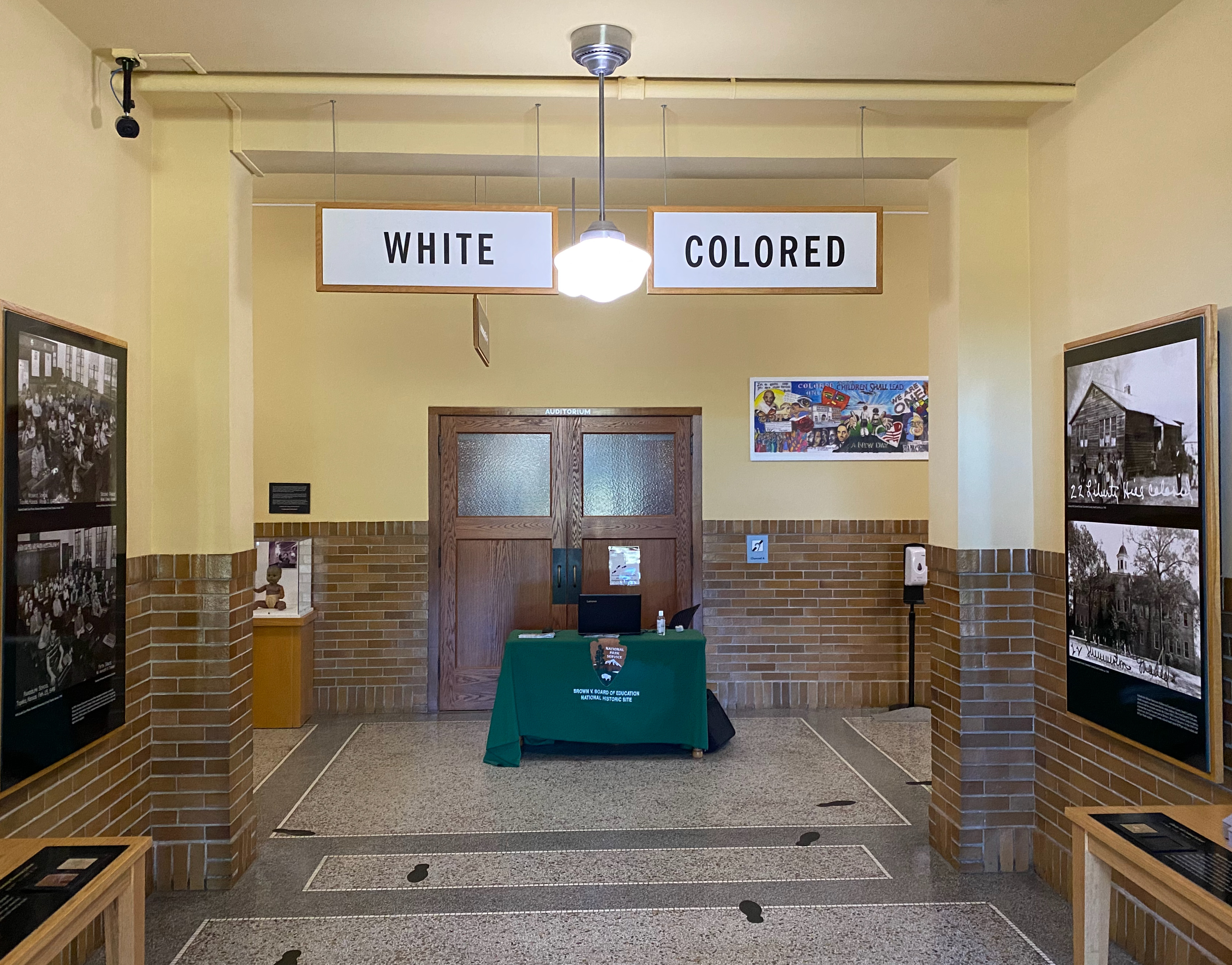
In 2004, Monroe Elementary became a museum for the history of post-Civil War segregation and the racism that still characterizes our society. The first thing you see upon walking in the door are the “White” and “Colored” signs hanging in the front hall (they were not there when it was a school for Black kids). The park ranger, a Kansas native, told me that every few months, a visitor bursts into tears upon crossing the threshold. We are within living memory of that America.
I went on to Kansas City. The next morning, my Warmshowers host, Mark, was pleased to bike with me 11 miles east to Independence. (Like a typical local, he’d never been.)
The end and the beginning
Why did the Oregon Trail begin at Independence? The Park Service ranger at Harry Truman’s house, our first stop, explained that the village was well watered by springs and four miles south of the Missouri, and Overlanders might arrive there by boat from St. Louis. In 1821, the Santa Fe Trail was established a hundred miles east at Franklin (following Lewis and Clark’s 1803 route). The Santa Fe was devised after Mexico defeated Spain, which like King George III had barred international trade between its New World colony and other countries. An infrastructure of suppliers—blacksmiths, wagon makers, merchants—had grown up by the time Independence was designated the Jackson County seat in 1827.
After standing in front of the Chicago & Alton Railroad station in town on Sunday, I returned Monday morning on my way east to find the site in McCoy Park I had biked past the day before. A gazebo shelters signs that explain the town’s early development, such as the mule-drawn railroad that rolled from the town square down to the river after 1849.
Independence is a beautiful town with stately homes. But like many similar communities, it’s been ravaged by covid. The Harry Truman house is closed because its rooms are too small. The National Archives’ Truman Presidential Library is closed. The trail museum, privately owned, has limited hours three days a week. Many storefronts on the otherwise handsome courthouse square are vacant. Amid the distress, one store keeps hours. “Wild About Harry” is “a shop for guys that caters to what guys like.”
My 13-day journey from the Trail’s end at Oregon City, a few miles up the Willamette from my home in Portland, leaves me with a couple conclusions. One is that life in the states in the late 1830s was tough. The Panic of 1837, brought on by the shrinking of credit that followed Andrew Jackson’s closure of the Bank of the United States (predecessor to the Federal Reserve), diminished opportunity. So did the South’s slave plantations. Striking out for the Willamette Valley or Salt Lake City or California held promise, encouraged by positive reports from waves of pioneers. One in 10 Overlanders died on the Trail from sickness, accidents, homicide, etc. That was about the same share of the population that died at home.
The other is the debt the Emigrants owed to all those who had gone before—other Overlanders, trappers and explorers before them, Indians, migrating ungulates that maintained trails across the continent for millennia. We are in their debt too. I drove on U.S. 26 and 30, which run along or parallel to Interstates 84 and 80, or state roads near them. Dirt and gravel strips followed the Oregon Trail, and the Trail followed the rivers: Missouri, Platte, Sweetwater, Snake, Columbia. We no longer know why we go where we go. But the mule deer remember.

